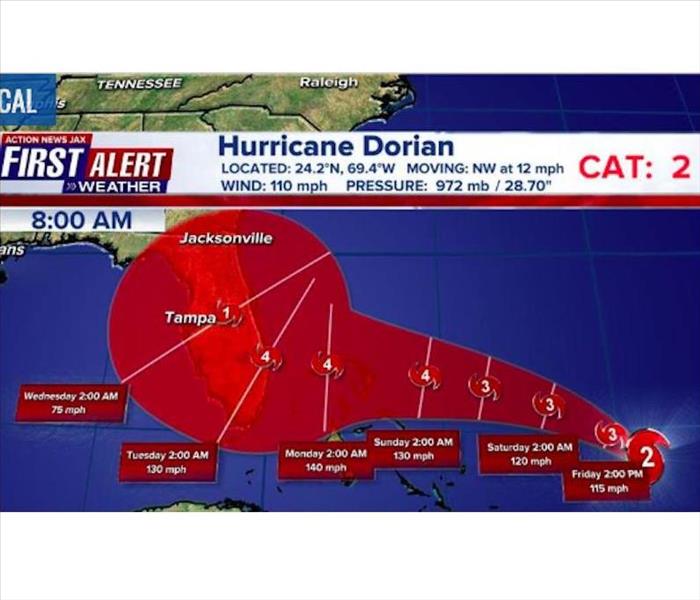
Latest Dorian Forecast, Local Impacts for Nassau/Duval
8/30/2019 (Permalink)
Source: WKOV
Jacksonville, FL - August 30, 8 AM: Dorian is now projected to make landfall early Tuesday morning with a Florida landfall as a category 4 hurricane. A Hurricane Watch has been issued for the NW Bahamas.
Maximum sustained winds are near 110 mph with higher gusts. Hurricane-force winds extend outward up to 25 miles from the center, and tropical-storm-force winds extend outward up to 105 miles.
There is a little nudge south but more changes and adjustments in the days ahead. The cone no longer includes much of SE Georgia. Action News Jax Chief Meteorologist Mike Buresh says there will still be some adjustments to the track but POSSIBLE Jacksonville/NE Fl./SE Ga. impacts (primarily Mon. into the middle of next week) & very dependent on exact location & intensity of Dorian:
* increasing & potentially deadly rip current risk at area beaches (as early as Fri. due to steady onshore flow). Always swim & surf with a "buddy" & as near a lifeguard as possible.
* rough seas & surf... some coastal flooding (accentuated by new moon phase Fri. in addition to occasional heavy rain) + above avg. tides at the coast, St. Johns River & its tributaries.
* breezy winds out of the east/southeast 10-20 mph, higher gusts.... peak wind gusts could reach 50+ mph early into the middle part of next week depending on positioning & strength of Dorian.
* several periods of heavy showers & t'storms, but it's not looking like a "washout" for the weekend.... wettest Monday & especially thereafter.
* isolated fast-moving tornadoes/waterspouts


 24/7 Emergency Service
