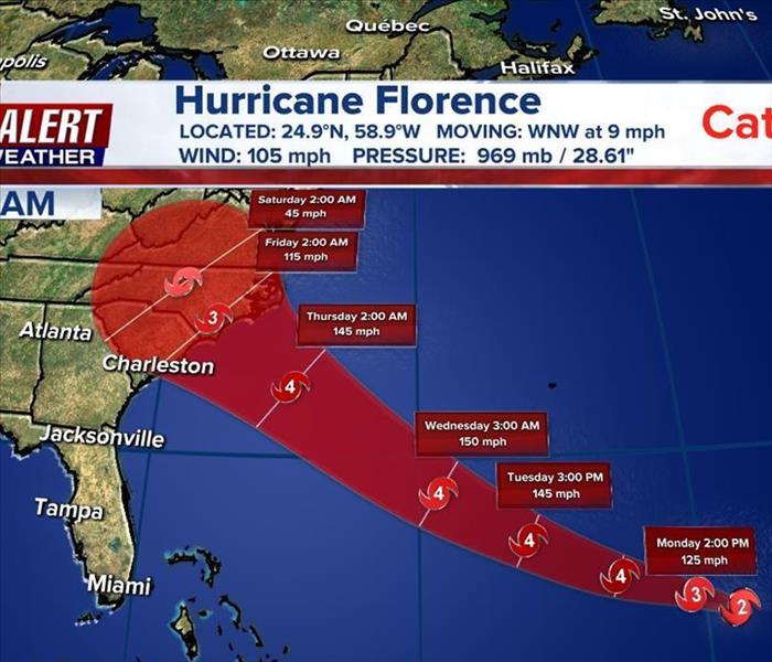
Hurricane Florence Now Category 3 – Expected Jacksonville Area Impacts
9/10/2018 (Permalink)
Source: Action News Jax
MONDAY 11 A.M. | Florence has regained strengthen and is now a category 3 hurricane.
JACKSONVILLE & VICINITY - FLORENCE IMPACTS: An increasing easterly swell at our beaches from distant Florence which will include a heightened rip current risk through Tuesday. Thereafter - primary impacts look to be a breeze & very rough seas/surf & rip currents AS LONG AS FLORENCE STAYS NORTH & EAST OF JACKSONVILLE - stay up to date on the latest & potentially changeable forecasts. In other words, on the forecast track, Florence locally will primarily effect the beaches & ocean. All boaters should stay in port beginning Wed.
As for the big picture, Hurricane Florence appears to be taking aim at the largest U.S. Marine Corps base on the East Coast.
Camp Lejeune has an extensive beachfront about 50 miles northeast of Wilmington and it's well within the National Hurricane Center's forecast "cone."
The hurricane's path is still far from certain Monday. The rapidly intensifying storm could strike a direct and dangerous blow anywhere from the Carolinas to the Mid-Atlantic region later this week, possibly as a fearsome category 4.
Since a recurve looks very unlikely, major to severe impacts can be expected on the South Carolina and North Carolina coasts.
As for the forecast models, there was a notable shift north over the weekend, but seemingly a recent stabilization pointing to the Carolinas. This could be because of the aircraft analysis that was ingested into the computer models Sat./Sunday.
Virtually all reliable global models are -- for now -- not far from Myrtle Beach. The UKMET model has shown the greatest shift north and is even north of the European and GFS models.


 24/7 Emergency Service
